
Price
$
Price Per
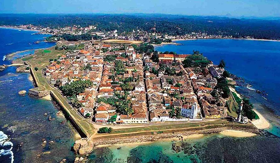
Galle Fort, in the Bay of Galle on the southwest coast of Sri Lanka, was built first in 1588 by the Portuguese, then extensively fortified by the Dutch during the 17th century from 1649 onwards. It is a historical, archaeological and architectural heritage monument, which even after more than 423 years maintains a polished appearance, due to extensive reconstruction work done by Archaeological Department of Sri Lanka.
The fort has a colourful history, and today has a multi-ethnic and multi-religious population. The Sri Lankan government and many Dutch people who still own some of the properties inside the fort are looking at making this one of the modern wonders of the world. The heritage value of the fort has been recognized by the UNESCO and the site has been inscribed as a cultural heritage UNESCO World Heritage Site under criteria iv, for its unique exposition of "an urban ensemble which illustrates the interaction of European architecture and South Asian traditions from the 16th to the 19th centuries.
Galle’s earliest historical existence is traced to Ptolemy’s world map of 125–150 AD when it was a busy port, trading with Greece, Arab countries, China and others. Its mention as a "port of call of the Levant" is made in the cosmography of Cosmas Indicopleustes. This is the harbour where the Portuguese, under the leadership of Lourenço de Almeida, made their first landing in 1505 on the island and caused a notable change in developments on the island with their close friendship with Dharmaparakrama Bahu (1484–1514), the then king of the country. Before the Portuguese arrived here, Ibn Batuta had touched base at this port. This was the beginning of the fort’s history, which was built by the Portuguese, along with a Franciscan chapel (now mostly in ruins) inside the fort in 1541. The fort also, in later years, served as prison camp to incarcerate Sinhalese natives who opposed the Portuguese. The Portuguese had moved to Colombo from Galle as they preferred the latter. In 1588, however, they were attacked by the Sinhalese King Raja Singha I (1581–93) of Sitawaka, which forced the Portuguese to return to Galle. At Galle, they initially built a small fort out of palm trees and mud. They called it the Santa Cruz, and later extended it with a watch tower and three bastions and a "fortalice" to guard the harbour.
In 1640, the events took a turn with the Dutch entering the fray joining hands with King Rajasinhe II to capture the Galle Fort. The Dutch, with a force of some 2,500 men under Koster, captured the fort from the Portuguese in 1640 itself. Although not an ideal situation for the Sinhalese, they were instrumental in building the fort as seen in its present form in the Dutch architectural style. Fortifications were added up to the early 18th century. The establishment consisted of public administration buildings, warehouses and business houses and residential quarters. A Protestant church (planned by Abraham Anthonisz) was also built in baroque style in 1775 to cater to the colonists and the local people who were converted to Christianity. The most prominent buildings in the fort complex were the Commandant's residence, the arsenal and the gun house. Other buildings erected in the fort catered to trade and defense requirements such as workshops for carpentry, smithy, rope making and so forth. They also built an elaborate system of sewers that were flooded at high tide, taking the sewage away to sea.
The British took over the fort on 23 February 1796, one week after Colombo was captured. Sri Lanka remained a British colony formally from 1815 till it became an independent island nation in 1948. The importance of Galle also declined after the British developed Colombo as their capital and main port in the mid nineteenth century.
The fort, originally built by the Portuguese in the 16th century to defend Galle, was an earthen structure with pallisades covering the northern inland side with a rampart and three bastions. They believed that the seaward side was impregnable and hence did not construct any fortifications on the sea side. The sea wall was an addition made in 1729 to make the city planning for defense purposes complete in all respects.
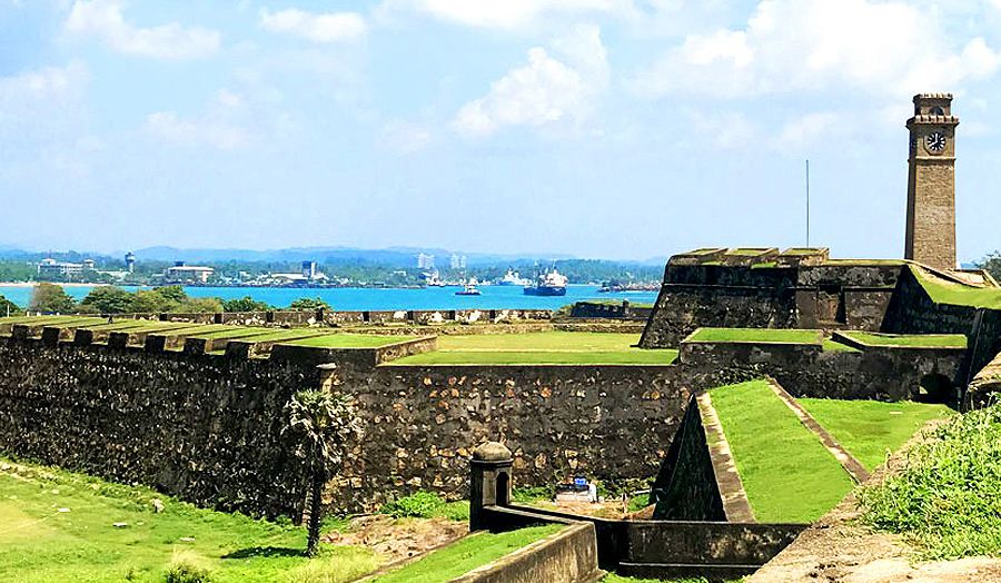
When the fort came under the control of the Dutch, they considered the old fortifications built by the Portuguese unsafe as they were made of earth and palisades. Hence, the Dutch decided to fully encircle the entire peninsula by building impregnable fortifications as defense against other colonial agencies in the region. They built some 14 bastions with coral and granite stones over an area of (52 hectares (130 acres)). Many of the fortification walls were built in 1663. The city built within the fort was well-planned with a grid layout and the peripheral roads aligned parallel to fort's ramparts.
The fort has two gates. The two towering gates to the fort are termed "Portcullised gates" and the first gate of entry from the port is inscribed "ANNO MDCL XIX" which has depiction of Dutch Coat of Arms with the ubiquitous emblem of cock and an inset "VOC" inscribed in the centre.
The Main Gate is along the northern stretch of the fort on the land side and is heavily fortified. The Portuguese had built a moat here which was widened during the Dutch rule by breaking the fort wall in 1667 and building the Star, Moon and Sun bastions. Its construction is also dated to the British period from 1897 to facilitate easy flow of traffic to the old town. This gate was fortified with a draw bridge surrounded by a moat; inscriptions here indicate 1669 as the year of construction. Some of the other named bastions are: The Aurora Bastion, the Tremon Bastion, the Kleipenberg Bastion and the Emaloon Bastion, adding an element of grandeur to the fort as a whole.
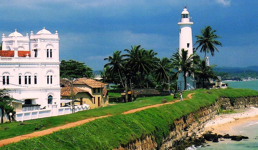
Walking along the fort wall in a clockwise direction leads to the Old Gate where the British Coat of Arms is seen inscribed at the entrance at the top. In the inner part of the gate there is the 1668 dated inscription of the letters VOC, an abbreviation of Verenigde Oostindindische Compagnie, meaning Dutch East India Company with the insignia of a cock flanked by two lions. Further along the fort wall is the Portuguese-built oldest bastion, known as Zwart Bastion, meaning Black Bastion. The eastern section of the fort terminates in the Point Utrecht Bastion; the powder house is also seen here. The 18 metres (59 ft) high Galle Lighthouse was erected here in 1938. The next stretch of the fort wall is the location of Flag Rock Bastion, which was used as a signaling station to warn ships entering the port of the hazardous rocky stretches of the bay. Ships were warned by firing musket shots from the Pigeon Island near the Flag Rock. Further along the fort walls is the Trion Bastion where a windmill drew water from the sea to sprinkle the dusty roads of the town; it is also a view point to watch sunsets. Many more bastions are seen along the fortifications from this location up to the Main Gate.
The Fort really resembles a small laid out walled town, with a rectangular grid pattern of streets full of the low houses with gables and verandas in the Dutch colonial style. It has a well laid out road network. The fort area also has a number of historic churches, mosques, commercial and government buildings. Some of the locals stroll along the walls of the fort in the evenings.
After the fort came under the control of the British in 1796, it remained their southern headquarters. They made many modifications to the fort such as closing of the moat, building of houses, a lighthouse on the Utrecht Bastion, a gate between the Moon Bastion and the Sun Bastion. A tower was particularly erected in 1883 to commemorate the jubilee of Queen Victoria. The Second World War saw many more fortifications built to defend the fort. In spite of all the changes made over the years, since it was first built between the 16th and the 19th century, the Galle Fort still remains a unique monument complex said to be "the best example of a fortified city with a fusion of European architecture and South Asian traditions built by Europeans in South and Southeast Asia
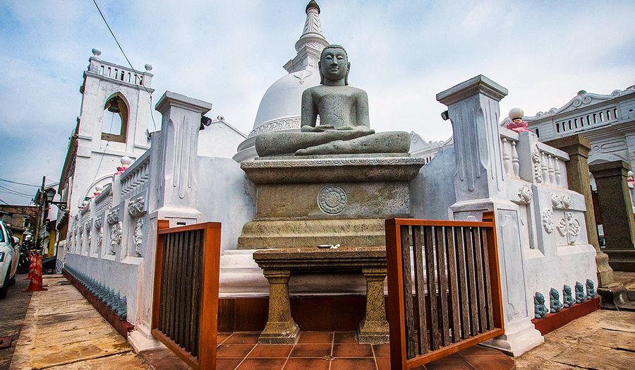
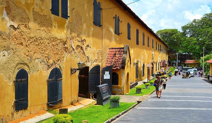
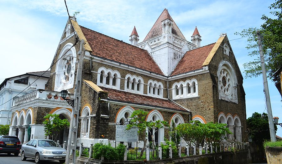
Some of the important heritage monuments in the fort are the Dutch Reformed Church, with its historic belfry dated 1707 and cast in 1709, which rang every hour; the old Dutch government house; the residence of the Commander; Great Warehouse near the Old Gate, built around 1669 to store spices and ship equipment (which now houses the National Maritime Museum); the Old Dutch Hospital; the Meera Mosque built in 1904; the Buddhist temple built at the site of Portuguese Roman Catholic church; the All Saints Anglican Church built in 1871; the 1882 Clock Tower and the 1939 Galle Lighthouse.
The Groote Kerk (Dutch Reformed Church) was built in 1640. However, it was remodeled between 1752 and 1755. The church is paved with grave stones from the old Dutch cemetery. There is an old organ of 1760 vintage in the church where services are held and a pulpit made of calamander wood from Malaysia is used.
The former New Orient Hotel was originally built in 1694 for the exclusive use of the Dutch Governor and his staff, it was converted into a hotel in 1865, the New Orient Hotel, which catered to the European passengers traveling between Europe and Galle Port in the 19th century and in 2005 was modernised into a franchise of the Aman Resorts, named the Amangalla.
The breadfruit (Artucarpus incisisus) tree was introduced in Galle first by the Dutch; reputedly the oldest breadfruit tree in Sri Lanka can be found at Akersloot Bastion in Galle Fort. It is believed that the Dutch introduced breadfruit which is of ‘heaty’ nature hoping that would either kill them or make them sick. However, the Sri Lankans found a neutralizer to this in the coconut tree. They mixed breadfruit with coconut and evolved a delicacy, which became popular, as it was found tasty and nourishing. This tree is now grown across Sri Lanka.

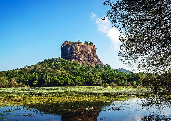
Sigiriya or Sinhagiri is an ancient rock fortress located in the northern Matale District near th...
View More
Destination for moderate hikes & climbs to the top of the rock, popular for panoramic views.
View More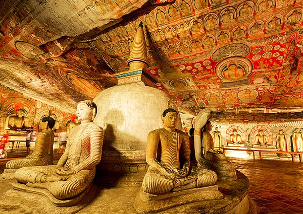
Dambulla cave temple also known as the Golden Temple of Dambulla is a World Heritage Site in Sri ...
View More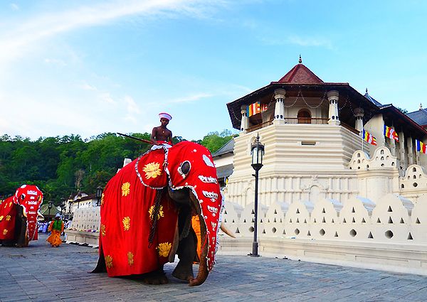
Sri Dalada Maligawa or the Temple of the Sacred Tooth Relic is a Buddhist temple in the city of K...
View MoreOur unbeatable rates ensure you receive the best deals for your purchase
We guarantee your safety with a secure payment gateway and ensuring 24/7 tour protection
Our experienced and outgoing travel agents are on hand 24/7 to help you throughout your tour
We provide you with clear guidelines that would make your stay more enjoyable and stress free